


les pénitents et leur forêt domaniale

stef789
User GUIDE
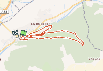

Length
11.4 km

Max alt
732 m

Uphill gradient
472 m
Km-Effort
17.7 km

Min alt
414 m

Downhill gradient
476 m
Boucle
Yes
Creation date :
2024-12-29 11:49:31.72
Updated on :
2024-12-29 16:51:47.921
5h00
Difficulty : Medium

FREE GPS app for hiking
 SityTrail
IGN / Geographical institutes
SityTrail Plus
The world is yours!
About
Trail Walking of 11.4 km to be discovered at Provence-Alpes-Côte d'Azur, Alpes-de-Haute-Provence, Les Mées. This trail is proposed by stef789.
Photos


44 photos in total. Please click on a photo to see them all in the gallery.
Positioning
Country:
France
Region :
Provence-Alpes-Côte d'Azur
Department/Province :
Alpes-de-Haute-Provence
Municipality :
Les Mées
Location:
Unknown
Start:(Dec)
Start:(UTM)
738464 ; 4879353 (31T) N.
Comments